Debby poses ‘major flood threat’ with heavy rain as storm center moves into Georgia
CHARLESTON, S.C. (WCBD)—Tropical Storm Debby is continuing its slow trek towards the Lowcountry’s coastal plain. The storm’s center is in southeast Georgia, and its outer rings are soaking South Carolina’s coastal counties.
Debby is moving six mph, down from the eight mph at 11 a.m. Monday. Storm Team 2 Meteorologist Rob Fowler says the slow movement will allow Debby to increase moisture and bring more rain to the Lowcountry.
National Weather Service forecasters predict Debby will move off the South Carolina coast late Tuesday and Wednesday, possibly allowing the storm to restrengthen before reapproaching South Carolina’s coast Thursday.
The storm’s maximum winds have decreased to near 50 mph, and forecasters say it will continue to weaken until possible re-strengthening on Wednesday and Thursday.
Debby was downgraded from a category 1 hurricane Monday morning.
As a result of Debby’s outer bands swatting the southeastern coast, several weather advisories are in effect for the area.
A tornado watch has been issued for Berkeley, Charleston, Colleton, Dorchester, Hampton, Beaufort, and Jasper counties until 1 a.m. Tuesday.
A storm surge warning is in effect for Charleston, coastal Colleton, tidal Berkeley, and coastal Georgetown counties. Flood and tropical storm warnings are also in effect for numerous counties.
For more detailed advisory information, click here.
August 5, 2024, saw record-breaking rainfall rates, with 2.29 inches falling, according to the National Weather Service office in North Charleston. The previous record was 1.78 inches, set in 1941.

EXPECTED LOCAL IMPACTS
HEAVY RAIN AND FLOODING
Threat level: EXTREME
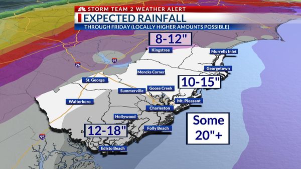
More than 10” of rain will fall across the Lowcountry through the end of the week. Severe flooding will be possible in some areas with significant damage to structures and roadways possible. Elevated tides and storm surge will worsen flooding along the coast.
TORNADOES
Threat Level: Elevated
Embedded thunderstorms will pose a risk of isolated tornadoes, particularly overnight Monday into early Tuesday.
HIGH WIND & POWER OUTAGES
Threat Level: Elevated
Gusts up to 50 mph will be possible, especially Tuesday through Thursday. With heavy rain and wet ground, there will be an increased threat of downed trees and power outages.
STORM SURGE
Threat Level: Elevated
Heavy rain and elevated tides will combine to increase the risk of flooding along the coast. As much as 2-4 feet of inundation will be possible along parts of our coast and along some tidal rivers and creeks through Thursday.


