

Ian now a hurricane heading toward Cuba, Florida
TAMPA, Fla. (WFLA) — Ian strengthened into a hurricane on Monday morning and is forecast to rapidly intensify into a major hurricane as it nears Western Cuba Monday night, the National Hurricane Center said.
Authorities in Cuba suspended classes in Pinar del Rio province and said they will begin evacuations Monday as Ian was forecast to strengthen before reaching the western part of the island on its way to Florida.
A hurricane warning was in effect for Grand Cayman and the Cuban provinces of Isla de Juventud, Pinar del Rio and Artemisa. The U.S. National Hurricane Center said Ian should reach the far-western part of Cuba late Monday or early Tuesday, hitting near the country’s most famed tobacco fields. It could become a major hurricane before a likely landfall in Florida around the middle of the week, possibly the state’s western coast or Panhandle
Cuba state media outlet Granma said authorities would begin evacuating people from vulnerable areas early Monday in the far-western province of Pinar del Rio. Classes there have been suspended.
At 5 a.m. EDT on Monday, Ian was moving northwest at 13 mph (20 kph), about 90 miles (150 kilometers) southwest of Grand Cayman, according to the center. It had maximum sustained winds of 75 mph (120 kph).
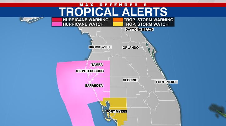
In Florida, much of the Tampa Bay area, including Hillsborough, Pinellas, Sarasota and Manatee counties, is under a Hurricane Watch, according to the NHC. This means those in the area could see hurricane conditions in the next two days. The watch is typically issued 48 hours before the anticipated first occurrence of tropical-storm-force winds, the NHC said.
There is also a storm surge watch in effect for much of the area, which could see 5 to 8 feet of storm surge in over the next 48 hours.
The storm is expected to near the Cayman Islands on Monday, then strengthen into a major hurricane when it nears Western Cuba Monday night.
The forecast track shows the storm emerging over the southeastern Gulf of Mexico as a Category 4 hurricane on Tuesday, according to Storm Team 8 Meteorologist Leigh Spann. The hurricane center said it should pass west of the Florida Keys late Tuesday, and approach the west coast of Florida on Wednesday.
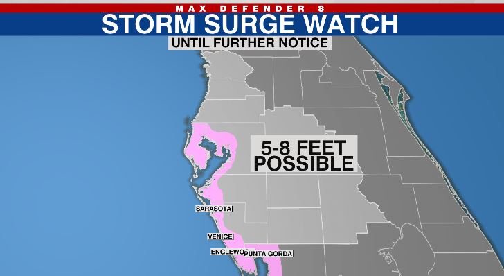
A Storm Surge Watch is in effect for:
- Florida Keys from the Card Sound Bridge westward to Key West
- Dry Tortugas
- Florida Bay
- Anclote River southward to the Card Sound Bridge,
- Tampa Bay
A Hurricane Watch is in effect for:
- Englewood to the Anclote River, including Tampa Bay
A Tropical Storm Watch is in effect for:
- Little Cayman and Cayman Brac
- Englewood southward to Chokoloskee
