

Tuesday’s winter storm brought high wind gusts and damaging conditions
CHARLESTON, S.C. (WCBD) – On Tuesday, a winter storm brought damaging wind gusts, severe thunderstorms, and dangerous conditions to the Lowcountry.
The squall line of the storm hit the Charleston metro area between 2 p.m. and 3 p.m., bringing hours of high winds and causing numerous power outages, with the Dominion Energy customer map showing over 40 thousand power outages across the state and over 20 thousand in the tri-county area around 5:30 p.m.
The bulk of the storms drifted into the Atlantic around 6:30 p.m. and continued to taper off in the Lowcountry.
This low-pressure storm system affected states up and down the East Coast and is still hitting Florida, with at least five tornadoes reported in the panhandle.
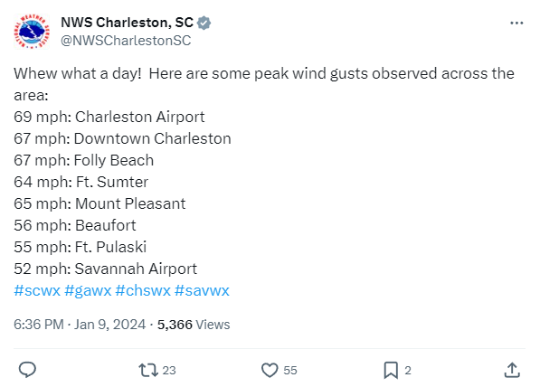
The National Weather Service (NWS) issued a high wind warning for the Charleston metro area for the first time in 12 years.
The wind ripped the siding off a home in Berkeley County.
Peak wind gusts were recorded as 69 mph at the Charleston International Airport, 67 mph in downtown Charleston and Folly Beach, and 65 mph in Mount Pleasant.
A tornado watch was also issued for Berkeley, Charleston, Colleton, Dorchester, Georgetown, and Williamsburg Counties until 6 p.m. A tornado was reported on the ground in Bamberg, SC.
Downed trees, power poles, and traffic lights going out caused street closures in Summerville, North Charleston, Mount Pleasant, Charleston, Charleston County, and Hanahan.


image 1: Katie Phillips, image 2: Charleston County Sheriff’s Office
The Isle of Palms saw extremely high surf and dangerous erosion, according to IOP Police. In addition, high surf crashed over the battery wall in downtown Charleston.
Charleston County issued a ‘code red’ warning for area bridges until further notice. High-span bridges – 65 feet or higher – are unsafe for travel. The ‘code red’ was issued shortly after a semi-truck overturned on the Ravenel Bridge, causing the bridge to close down.

The northbound lanes remain temporarily closed as police have not been able to remove the semi-truck.
“Anyone who drives over bridges against the advisory is doing so at their own risk,” the county said.
Georgetown County has a wind advisory remaining in effect until 6 a.m. on Wednesday, with gusts up to 50 mph possible.
Because of the severe weather threat, several school districts moved to eLearning for Tuesday, including Georgetown, Berkeley, Dorchester, Charleston, Dorchester District Two, Colleton, and Williamsburg Counties.
Many of these districts will have a delayed start on Wednesday to assess storm damage to school facilities.
The Charleston County Public Libraries will also have an hour-delayed opening on Wednesday to assess the damage.
Colleton County received 142 damage reports regarding downed trees, lines, and debris, with Colleton Fire monitoring throughout Tuesday night.
